Live from SmallSat Europe 2026
I joined a panel on ‘ISR from space’ at SmallSat Europe in Amsterdam back in May, alongside colleagues from ICEYE, Satrec Initiative, and European Space Imaging. The conversation covered a lot of ground - sovereign capabilities, the fusion of SAR and optical data, peacetime versus wartime tempo, and the implications of ESA's new European Resilience from Space programme.
The demand for sovereign, resilient space-based ISR is accelerating - that much is clear. NATO members are acquiring their own SAR systems. ESA is, for the first time, explicitly operating in a defence capacity with a €1.35 billion programme. The policy conversation has shifted decisively. But underneath this momentum, the panel brought up something which I think deserves more attention: European ISR is investing heavily in the wrong part of the problem.
The straw problem
A high and ultra-high resolution satellite is, in the words of Space Inventor CTO Peter Davidsen, like looking through a straw from 500 kilometres away, down to Earth. The capability is extraordinary, no doubt, but only if you know where to point it and what to look at. Otherwise 99% of the time you don’t see anything. That’s where tipping and cueing comes in. [20:59]
When defence and government agencies are justifying ISR budgets, the high resolution assets are the easiest to sell - they’re tangible, the imagery is demonstrable, and the capability is hard to argue with. So the cue - the high res optical or SAR satellite - helps ensure the image gets funded. What’s harder to justify, and therefore underfunded, is the tip: the wide-swath sensors, the RF detection payloads, the navigation warfare monitoring that tells you where something is happening, before you task an expensive asset to go and look. [37:42]
The result is a system that’s technically impressive but structurally incomplete; Europe has been focused on building the straw (the cue), and now it’s time to widen our horizons to include the tip.
What proven solutions actually look like
At Space Inventor we’ve spent the past decade building the kind of integrated, mission-proven capability that this moment demands.
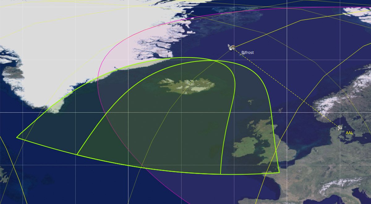
The first satellite built under contract with the Danish military - and still being operated by Space Inventor - is in orbit right now, sensing RF signals from dark ships around the Arctic. That mission - BIFROST - is exactly the kind of tipping asset the broader ISR architecture needs more of: wide-area, persistent, actionable intelligence fed into the chain before the high-resolution assets are ever tasked. [07:49]
Bifrost revealed one of the most under appreciated threats in European ISR: GNSS jamming and spoofing. Around the Baltic area we experienced GNSS degradation on the satellite itself. This caused more than operational disruption, since Bifrost’s core function is RF detection (electronic warfare). Clearly we need precise geolocation of RF emitters at sea; however, if our own GNSS is being degraded, we must recognize this threat and ensure our onboard systems are prepared to adapt. This proves to us that navigation warfare (GNSS jamming and spoofing) and electronic warfare are not separate problems - one feeds into the other. [12:23]
That experience directly informed our work on BeaconSat, developed with Austrian Defence - Austria's first military satellite, which detects GNSS jamming and spoofing. What the panel’s discussion reinforced is that GNSS interference is not just a technical nuisance - it’s an early warning signal, which tends to precede other activities. So a capability that detects it is an early warning system for broader threat escalation. [12:00]
Bifrost, BeaconSat, and several other NATO countries we’re working with have proven that there’s a real problem here, and real need, which we can fulfil with this capability. [08:27]
Integration is the gap in European ISR
Europe has been fairly open about where the gaps are. The ESA ERS InFocus missions - IoD A, B, C, D - actually name them directly: sensors, tasking, data latency, and agile spacecraft. That’s the ESA clearly saying these are the areas where more demonstration is needed, and where consortia need to come together to build solutions. [25:29]
What the panel discussion reinforced is that each of those gaps has its own application-specific needs, which makes them harder to solve. Take data latency: if you're sensing something in Ukraine and you see a tank moving, you have a matter of seconds to act. If there's a large ship moving in the Arctic, you might have minutes. Those are problems requiring different architectures. The same is true of resolution: you need very high resolution for some things, and wide-swath, lower resolution coverage for others, like RF emitter detection. [25:48]
Processing is also a good example of this problem: a defence agency that needs to take action wants insights processed on board and sent down. But an intelligence agency wants the opposite - all of the raw data, unprocessed, so it can be worked through by analysts later. Those are different requirements on the same processor. Ukraine made the stakes of that distinction concrete. When a tank is moving, the relevant timescale is seconds. The insight has to arrive in time to act on it - not after it has passed through a processing pipeline designed for a different kind of customer. Situations and applications like these create a very mix-and-match set of challenges that need to be fitted into specific solutions for defence customers. [26:10]
On Bifrost, we solved one version of this problem directly: we have an RF inter-satellite link to GEO. So, the satellite detecting dark ships in the Arctic processes insights on board, and sends it via an RF link to an Inmarsat satellite, which relays it so that Danish and Swedish MoDs can access the data. The insight arrives in time to act on it. The raw data can then be followed later for deep intelligence processing. [27:15]
The conversation that matters
European ISR needs credible, proven solutions. Not a single capability, but the full mix: high resolution optical and SAR for the cue, RF detection and navigation warfare monitoring for the tip, and onboard processing that can separate insight from the raw data, and route it where it needs to go. The gaps are known, the application-specific logic of each one is understood, and the consortia to address them are forming.
One thing that the panel agreed on is that the solutions ESA is looking for cannot come from a single company. They require consortia - organisations that know each other's capabilities and can combine them into something that is greater than the sum of its parts. What I found at SmallSat Europe is that the work is already happening; companies that know each other's capabilities, confronted with concrete proposals, are finding ways to combine them into something genuinely integrated. That is how unique solutions get built. [41:35]
Rewatch the panel on ISR from space here:
Popular articles